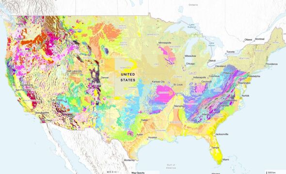
A new interactive geologic map released by the U.S. Geological Survey (USGS) offers a comprehensive view of the rock formations beneath the surface across the United States. Unveiled in August 2023, this innovative tool represents three years of extensive research and builds upon decades of previous geoscientific work. The map allows users to explore various rock types and sediment layers, providing insight into their ages and characteristics.
The interactive nature of the map enables users to search for specific geological properties or click on different sections for detailed information and links to local geologic maps. According to Joseph Colgan, a USGS research geologist and leader of the mapping team, “This map provides complete, analysis-ready geologic data for the nation, in a format that is easy to expand going forward.” The aim is to enhance educational engagement and foster a broader appreciation of geology among the public.
Innovative Mapping Techniques
A significant advancement in this project was the development of a faster, largely automated process that combines geological data from both State Geological Surveys and the USGS. This method allowed researchers to create the map in a fraction of the time typically required for such a large-scale project. As noted by Sam Johnstone, a USGS research geologist and lead developer, “Ongoing mapping efforts continually make new discoveries, but past national maps took decades to create, while our new method allows us to update our national map faster than ever before.”
The new map is part of a collaborative effort involving the Association of American State Geologists and the National Geologic Map Database. This initiative aims to standardize geological mapping across the country, making it easier for experts and the general public to access vital geological information.
Applications and Future Developments
The applications of the map are vast, as highlighted by Christopher Swezey, the USGS National Cooperative Geologic Mapping Program coordinator. “Geologic maps have many uses, such as helping experts look for energy, mineral, and water resources,” he stated. Additionally, these maps can play a crucial role in assessing earthquake risks and informing decisions related to land use, infrastructure, community planning, and even real estate insurance.
Despite its advancements, the map remains a work in progress. According to Eos.org, there are still inconsistencies in how geological data is collected and published across different states. For example, the Idaho-Washington border highlights discrepancies, as each state provided differing information about the rock layers near the border. Johnstone mentioned that “such disparities are unavoidable on the new map,” emphasizing the goal of integrating data without altering the original interpretations. These differences present opportunities for future collaboration between state agencies and the USGS to improve data uniformity.
The release of this groundbreaking map marks a significant step forward in geological research, providing essential resources for both the scientific community and the public. As more discoveries are made and the map evolves, it promises to deepen our understanding of the geological landscape beneath our feet.