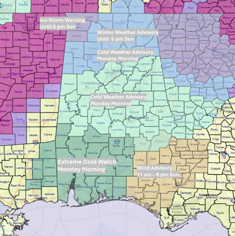
UPDATE: Severe weather is impacting Alabama this weekend, with the Alabama Emergency Management Agency issuing urgent warnings for freezing rain, severe storms, and dangerously cold temperatures. As of January 24, 2026, at 2:00 PM, forecasts indicate an unchanged threat for freezing rain and sleet north of I-20.
Authorities have upgraded the risk for severe storms to a Slight Risk in southern Alabama, with a Marginal Risk extending northward to I-20 by Sunday. A Wind Advisory is in effect for southeastern sections late Sunday morning through the afternoon, signaling potential hazards.
As of 1:00 PM, temperatures remain below freezing in areas north of the Vernon-Cullman-Scottsboro line. However, forecasters predict a rise in temperatures above freezing between 5:00 PM and 8:00 PM, except for the far northwestern counties, which are under an Ice Storm Warning.
The bulk of the rain is expected to occur tonight through Sunday afternoon. A line of showers and thunderstorms will sweep across the state from west to east, starting from mid to late Sunday morning into early evening. Regions south of I-20, particularly south of the Livingston-Montgomery-Auburn line, could experience wind gusts between 40-60 mph, with the potential for tornadoes.
In addition, pressure gradient winds in southern Alabama could gust up to 30 mph ahead of the storm line from late Sunday morning through the afternoon. Following the storms, a surge of very cold air will filter into the state. It now appears there will be little transition to freezing rain or snow as temperatures drop below freezing, though some snow flurries may occur Sunday night into Monday morning.
Residents should prepare for extremely cold conditions, with gusty winds reaching up to 30 mph expected from Sunday night through Monday afternoon. This rapidly changing weather poses significant risks, and officials urge everyone to stay informed and take precautions as these severe weather events unfold.
Stay tuned for further updates as the situation develops.