Researchers from The University of Melbourne have unveiled a groundbreaking deep learning framework named Themeda, designed to improve the accuracy of land cover predictions. Published in the Journal of Remote Sensing on September 11, 2025, this innovative model aims to address the complexities of land cover changes, particularly in tropical savannas, which are critical ecosystems facing rapid habitat loss.
Land cover changes have significant implications for erosion, water quality, fire regimes, and species habitats. Despite advances in remote sensing technologies, accurately forecasting these changes remains challenging due to the need to integrate diverse environmental factors and temporal variability. Tropical savannas, which occupy one-sixth of the Earth’s terrestrial surface, present unique modeling challenges due to their seasonal rainfall patterns, frequent fires, and high vegetation diversity.
Introducing Themeda: A New Approach to Ecological Forecasting
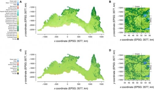
Themeda leverages advanced neural network architectures alongside multi-decadal satellite observations, achieving an impressive accuracy rate of 93.4% for FAO Level 3 land cover categories. This performance significantly surpasses traditional methods, which typically hover around 88.3% accuracy. The model’s validation tests demonstrated nearly a tenfold reduction in prediction errors, with Kullback–Leibler divergence values as low as 1.65 × 10⁻³.
In the development of Themeda, researchers utilized both ConvLSTM (Convolutional Long Short-Term Memory) and a new Temporal U-Net design. This combination allows for the processing of spatiotemporal data at multiple scales, integrating 23 land cover classes with various environmental predictors, including rainfall, maximum temperature, fire scars, soil fertility, and elevation. The data covers an extensive period from 1988 to 2020.
The model’s predictive capabilities were rigorously tested, revealing that rainfall emerged as the most significant predictor, followed closely by temperature and late-season fire scars. Notably, Themeda maintained its predictive power even in untested years and regions, although it faced challenges during extreme climatic conditions, such as the notably hot and dry season of 2019.
Practical Applications for Land Management and Conservation
The insights generated by Themeda extend beyond mere academic interest. The probabilistic outputs offer pixel-level classifications and landscape-scale insights, making the framework suitable for integration into hydrological, fire, and biodiversity risk models. This capability supports proactive land management strategies, allowing communities and policymakers to anticipate ecological risks rather than respond after issues arise.
Lead author Robert Turnbull emphasized the transformative potential of Themeda, stating, “Our findings show that deep learning can move beyond static mapping toward dynamic forecasting of ecosystems. By learning from decades of environmental data, Themeda provides predictions that are not only accurate but also transparent about uncertainty.”
As climate extremes intensify, the predictive capacity offered by Themeda is crucial for safeguarding biodiversity and sustaining livelihoods, particularly in vulnerable regions like Australia’s savannas. Beyond its local applications, the framework’s methodology can be adapted to various biomes worldwide, addressing global challenges related to food security, biodiversity loss, and sustainable resource management.
In summary, Themeda represents a significant advancement in integrating artificial intelligence with ecological forecasting. It presents practical benefits for land management, climate adaptation, and conservation planning, including supporting erosion control, hydrological modeling, and fire management strategies.
This research was supported by The University of Melbourne’s Research Computing Services and the Petascale Campus Initiative, with additional resources from the National Computational Infrastructure (NCI), supported by the Australian Government.
For more details on this study, refer to the complete research article at DOI: 10.34133/remotesensing.0780.