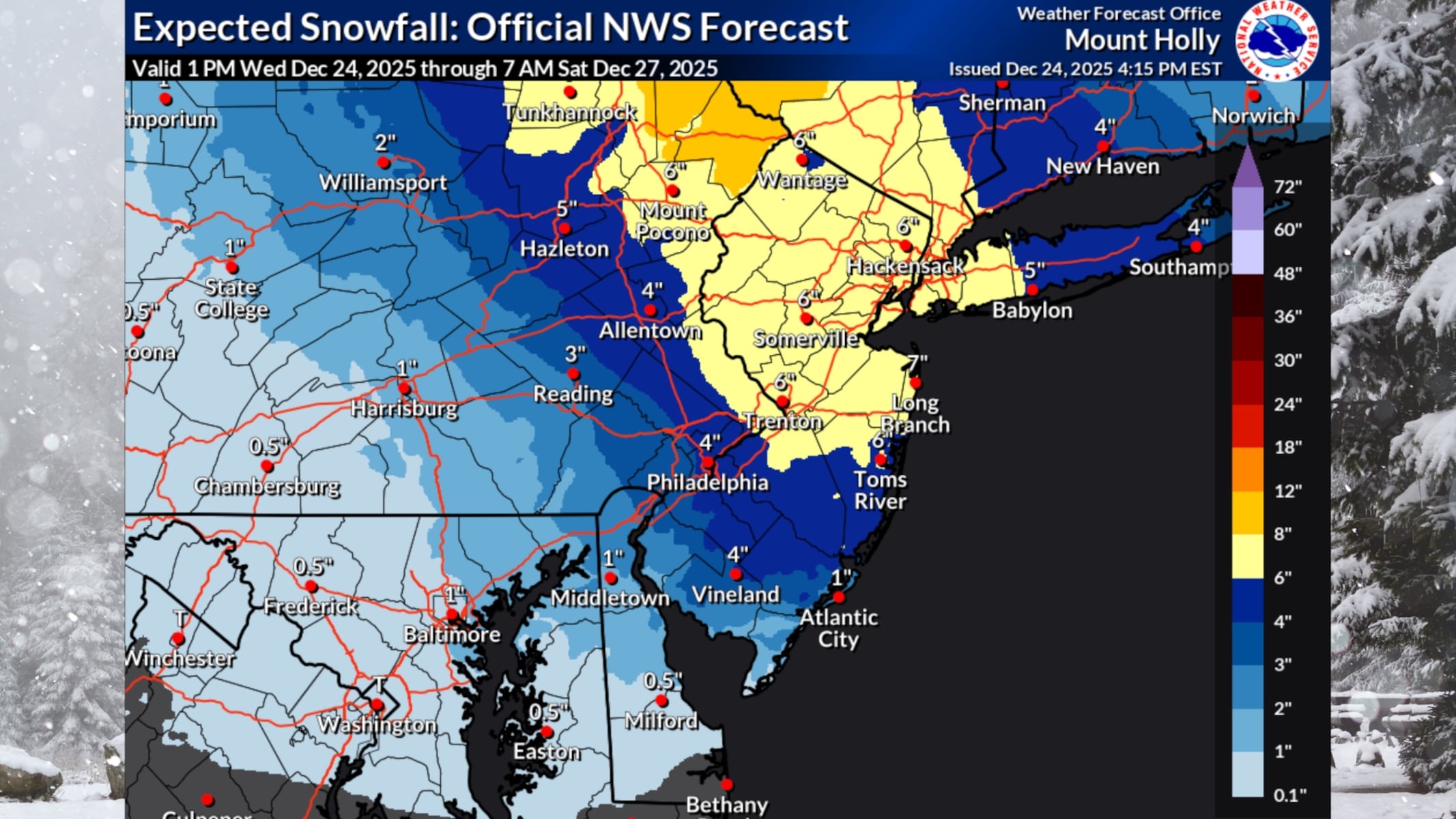
New reports confirm a major winter storm is set to blast New Jersey on December 26, 2023, bringing 4 to 8 inches of snow and the threat of dangerous ice. Travel disruptions are expected as the National Weather Service issues winter storm watches for 16 counties across the state.
The storm is predicted to start affecting conditions on Friday afternoon, with the heaviest snowfall occurring overnight and tapering off by Saturday morning. Forecasters warn that some areas could see total accumulations of up to a foot, particularly in northern New Jersey.
“This fast-moving storm will pack a punch in the Northeast right after Christmas,” stated AccuWeather Senior Meteorologist Tyler Roys. “Holiday travelers should prepare for major slowdowns on roads and at airports.”
The National Weather Service highlights that the storm will primarily be an all-snow event for regions north of I-195, while areas south of I-78 may experience a mix of snow, sleet, and rain, with snowfall totals potentially reaching only 2 to 4 inches.
Winter storm watches are in effect from Friday afternoon through Saturday morning for counties including Hunterdon, Mercer, Middlesex, Monmouth, Morris, Sussex, and Warren, where heavy snow accumulations of 5 to 8 inches are anticipated. Residents in Bergen, Essex, Hudson, Passaic, and Union counties should also prepare for similar conditions, with total snow accumulations of 4 to 8 inches.
Areas near the Delaware River are at risk for a hazardous layer of ice due to the wintry mix, creating perilous travel conditions. Meteorologists advise delaying all travel if possible.
As Christmas Day approaches, the weather will remain mostly cloudy with temperatures in the 40s, before dropping significantly on Christmas night. By Friday morning, temperatures will fall into the teens in northern regions and into the low to mid 20s further south.
Looking ahead, Sunday will see increasing clouds and potential rain across New Jersey, with temperatures rising overnight into Monday. Cold, blustery conditions are expected next week with highs around freezing.
Residents are urged to stay updated on the latest forecasts and monitor conditions closely as the winter storm approaches. Stay safe and plan accordingly for what could be a challenging travel weekend.