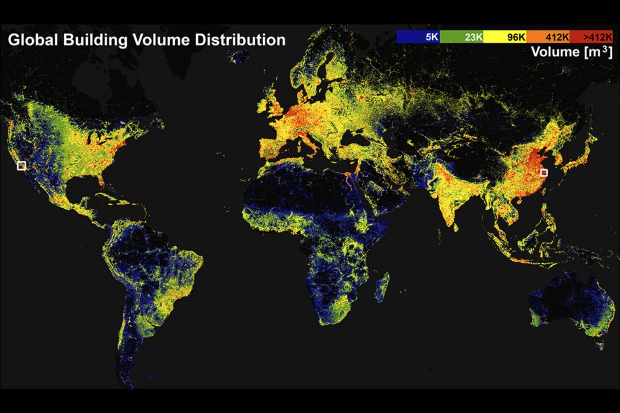
URGENT UPDATE: A groundbreaking new resource has just been launched—the GlobalBuildingAtlas, a high-resolution 3D map showcasing every building on Earth. Developed by a team at the Technical University of Munich (TUM) in Germany, this revolutionary map features an astonishing 2.75 billion building models, sourced from satellite images collected since 2019.
The GlobalBuildingAtlas represents a significant advancement from the previous dataset, which included only 1.7 billion buildings. The new map boasts a resolution that is approximately 30 times finer than comparable databases, providing a detailed view that is set to impact urban planning, socioeconomic studies, and climate research.
WHAT THIS MEANS FOR YOU: This innovative tool is not just a visual marvel; it has profound implications for understanding urbanization and poverty. According to Xiaoxiang Zhu, the lead author and data scientist at TUM, the map serves as a critical resource for assessing the “footprint” of urbanization and can highlight social and economic disparities in various regions.
The map was officially detailed in the journal Earth System Science Data on December 1, and is now accessible to the public. Users can interact with the map, entering specific addresses to view building placements and elevations. The interactive features allow for a customizable experience, making it easy for anyone to explore urban landscapes across the globe.
Research indicates that understanding the distribution of buildings can also aid in climate studies. The data collected can improve models related to energy demand and carbon emissions, an urgent consideration in the face of climate change. Agencies like the German Aerospace Center have already expressed interest in utilizing this comprehensive resource to assess risks from both natural and human-made disasters.
The researchers have emphasized the importance of including often-overlooked regions in their mapping efforts, such as parts of Africa, South America, and rural areas worldwide. This inclusivity ensures a more accurate representation of global building metrics, such as building volume per capita, which can be instrumental in analyzing socioeconomic conditions.
As the world grapples with urban challenges, the GlobalBuildingAtlas promises to be an essential tool for policymakers and urban planners. “Buildings anchor human life and define the form and function of urban environments,” the research team stated.
WHAT TO WATCH FOR NEXT: As the map gains traction, anticipate further developments in its application for urban planning and environmental studies. The ability to visualize and analyze building data could reshape how cities are designed and managed, especially in resource-limited contexts.
For those eager to dive into this remarkable resource, the GlobalBuildingAtlas is available for exploration, with options to download data and code from GitHub. This exciting development is not just for scientists; anyone can engage with this interactive tool and gain insights into the architectural landscape of our planet.
Stay tuned as this story develops, and explore the GlobalBuildingAtlas to witness the incredible scale and detail of buildings worldwide.